GIS Production Services
Custom GIS production solutions for local governments and appraisal districts—accurate, compliant, and fully supported.

Our Partners
The Challenge: Maintaining GIS Data Can Feel Like A Losing Battle
GIS Data is central to local government operations a well-maintained geographic information system is the key to optimizing your workflow. However, maintaining the spatial data can be overwhelming, and with daily updates and changes, it can get out of date fast. GIS production services should support your workflow, help you in accurate land use planning, and provide production mapping that is both accurate and easy to use. BIS provides GIS production services and maintenance to keep your information technology systems running smoothly.
We Put You in the Driver’s Seat of Your GIS Data
At BIS, we provide a wide range of end-to-end mapping, modeling, and maintenance services to meet your needs. Whether you’re a county, city, water district, or 911 agency, we tailor solutions for your regulatory, operational, and citizen engagement needs.

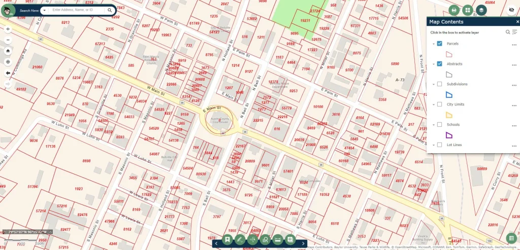
We create detailed, custom maps tailored to your specific needs. Our map service provides visualizations that help your team and the public better understand land data.
Our team helps collect and integrate data where you need it to make sure your GIS database is comprehensive and up-to-date.
Our team provides ongoing maintenance that keeps your GIS data accurate, adapted to system updates or changes, and ready to use.
Spatial analysis helps local governments identify trends, patterns, and relationships within their GIS data.
Consult with our experts on GIS workflows, optimization, data accuracy, and how to maximize the value of your GIS syste
How it Works: 5 Steps to Your New GIS System
Free Consultation
Our team works with you to identify your organization’s needs, goals, and existing MPS and GIS systems. We then discuss our GIS production services and what would be best for your needs.


Data Collection & Processing
Our team collects and processes geographical data, building a cohesive GIS database.
Custom Map Production
Using the GIS data we’ve collected, we build maps and visualizations based on your goals, needs, and specifications.

Spatial Analysis
We perform an advanced analysis of your geographic data to provide insights and recommendations.
Ongoing Support & Maintenance
Our team provides ongoing maintenance, continuous support, and monitoring to keep your GIS data accurate and functional.
Our clients have the option to reach us by phone, email, Zendesk Ticket, or remote IT service when they need support.

Why Work with
BIS Consultants
We’re on a mission to provide the best technology solutions for government entities like appraisal districts, counties, water districts, emergency services, and beyond. Make your technology woes a thing of the past when you bring in the experts at BIS Consultants.
ESRI Partner
As a trusted ESRI GIS Partner, we offer our clients cutting-edge solutions that are fully compatible with ESRI’s suite of products.
Accuracy
Utilizing the latest technology and methodologies, we ensure your GIS data is precise and reliable.
Customization
We create solutions that are custom-tailored to align with your goals, needs, and objectives.
Expertise
Our team brings decades of experience in GIS production, map production systems, and local government operations.
Efficiency
We’re professional streamliners for the GIS process- delivering high-quality data and maps quickly and accurately so you can get back to the other 10,000 tasks on your plate.
Cost-Effective
Our pricing is competitive, and we offer scalable GIS production services, making sure you receive the best value for your investment.
Hear It From Our Clients…
“First rate service. I also love how BIS is always educating clients on new and emerging trends. It's good to have a trusted partner.”
Case Study: Our GIS Production Solution for Lampasas CAD
The city of Austin, Texas, is experiencing rapid growth which is causing surrounding counties like Lampasas to evaluate their appraisal processes. Juggling GIS maintenance needs while relying on inaccurate data to drive decision-making wasn’t working. We stepped in and helped unlock the full potential of data-driven planning.
Lampasas CAD
Lampasas County Appraisal District knew it needed a more robust and integrated GIS system to manage appraisal initiatives. They struggled with inefficiencies, a lack of data-driven decision-making, and poor public-facing engagement opportunities. We jumped in to help!
An Efficient, Customized GIS Ecosystem
We created an integrated GIS ecosystem for Lampasas CAD and empowered their team to utilize this system to increase efficiency, enhance decision-making, and improve citizen engagement.
Read the full case study here or explore more case studies.
FAQs About GIS Production
What Are GIS Production Services?
GIS Production Services involve creating, maintaining, and managing geographic information systems. This is done through data collection and organization, map creation and design, charts, and other specialized visualizations.
What Types of Organizations Use GIS Production Services?
Government agencies such as County Appraisal Districts, Emergency Services, Water Districts, Rural Cities, and 911 Districts utilize GIS data every day to track, analyze, and visualize geographic information.
Businesses like utility providers, technology companies, delivery services, telecommunications providers, real estate companies, insurance agents, agricultural companies, and more leverage GIS data to help make informed business decisions or map out the best routes for their services.
Can You Help Get My GIS Data Up to Date?
Yes! We understand how easy it is to fall behind on your GIS data and are experts in getting your CAD up to date and maintained for the future, so you’ll always have accurate GIS data at your fingertips.
What is the Difference Between ArcGIS and GIS?
GIS stands for Geographic Information System– which is a broader term that encompasses all GIS systems. ArcGIS is a specific software platform by ESRI that many local governments and businesses use to organize and visualize their GIS data.
We are an ESRI Partner and work with both ArcGIS systems and others. We can help you create and guide you to the right system for your goals and needs.
Can BIS Help Us Prepare for a MAP Audit?
Yes. Geographic data plays a huge role in a comprehensive assessment of a Marketing Automation Platform (MAP). Providing a spatial perspective, visual data allows auditors to see MAP data in a more intuitive way and to uncover patterns and relationships that might not have otherwise been apparent.
GIS can play an important role in your marketing strategies– contact us today to learn more about how we can help you prepare for a MAP audit.
Who Would We Be Working With?
Our team of experts works hard to make sure you feel supported every step of the way. Book a free consultation to say hello and learn how we can help with your GIS production needs!
GIS Production, Simplified
Ready to leverage the full power of GIS for your org? We’re standing by to help. Contact us today to book your free consultation and get started on a GIS improvement journey!