We Transformed Mobile Field Work for Edward County CAD
Edwards County Central Appraisal District (CAD) needed to take their parcel map into rural areas where cell service isn’t guaranteed. BIS delivered a mobile field appraisal workflow that reduces paper handling, captures photos and notes in the field, and syncs updates back to office systems once online.
A quick snapshot of what improved for the field teams.
~3 weeks saved
Annual time savings reported by Edwards CAD leadership.
Offline-ready workflow
Parcels cached before leaving the office for rural field work.
Paper reduced
Attributes, photos, and notes captured digitally in the field.
Systems stay in sync
Updates flow to CAMA and align with existing ArcGIS layers.
The Challenge
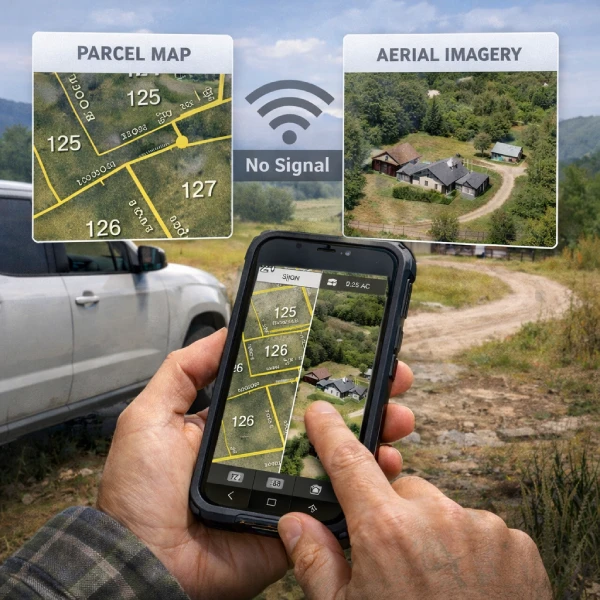
Edwards County sits on the Edwards Plateau in Texas—about 1,400 residents spread across a little over two thousand square miles. The CAD team appraises property for Texas ad valorem taxes and already had a digital parcel map in ArcGIS. The missing piece was a dependable mobile field appraisal app for rural areas with inconsistent connectivity.
What wasn’t working
The team could view parcels online, but needed to take the parcel map into the field, often without cell service. While also reducing paper handling and keeping field updates accountable.
What success required
Parcel map access in the field
Current imagery base layer
Key attributes per parcel
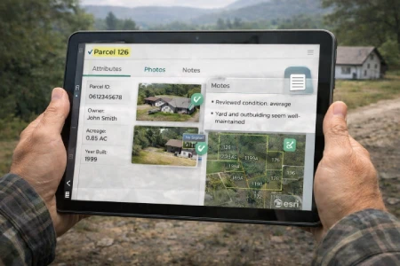
Field collection: attributes, photos, and notes
Less paper in day-to-day appraisal work
What BIS built
BIS delivered a mobile field appraisal workflow that integrated smoothly into existing systems. Field data updates the CAMA database once appraisers return to connectivity, and the solution aligns with ArcGIS mapping operations. BIS also provided training for ArcGIS users.
Field-First Mapping
Parcel map + imagery access
Appraisers can view parcel layers and current imagery while on-site, without relying on a stable connection.
Structured capture
Attributes, photos, notes
Field teams collect the details that matter, attach photos and notes directly to parcels for a cleaner workflow.
Offline + Sync
Cache parcels, sync later
Parcels in low-service areas can be stored for offline use before heading out, then synced back at the office.
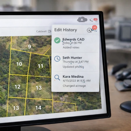
Accountability
Who changed what
Edwards CAD requested visibility into which appraiser made field updates, supporting consistency and traceability.
Navigation
Route to a parcel
From a selected parcel, field teams can generate a driving route from their current location to the site.
Adoption
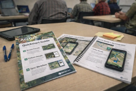
Training included
BIS trained ArcGIS users on how the systems work together, so the workflow is usable, not just delivered.
Integrated with ArcGIS + CAMA
Minimal security required (public domain data)
The outcome
The ArcGIS Collector Application was tested in the field and is now an invaluable part of the appraisal system by speeding up inspections, reducing paper handling, and keeping field data synced with office tools.
" Whenever we have to do a site inspection, we just grab the tablet and go. "
— Edwards County Central Appraisal District
Efficiency gains
At least three weeks of field time saved each year.
Renn Riley (Chief at Edwards CAD) shared that these changes save their team significant time annually and made site inspections dramatically simpler.
Tablet-first inspections replace paper-heavy prep
Attributes, documents, and notes stay connected to each parcel
Less rework once the team returns to the office
Field validation
Tested in real conditions, built for rural reality.
BIS rode along with a CAD appraiser to validate the workflow in the field. Parcels were stored for offline access before leaving, then synced back to office systems upon return to connectivity.
Offline parcel access in low-service areas
Reliable capture of photos, notes, and attributes
Seamless upload and system alignment after the field day
Acknowledgements: Thanks to Renn Riley (Chief at Edwards CAD) and Darren Sullivent (Senior Field Appraiser, Llano Central Appraisal District) for field testing and feedback.
Let BIS create a mobile application for your CAD
The BIS Mobile Map Application helps appraisers reduce workload, speed up the appraisal process, and keep field work seamlessly connected to office systems.