
CASE STUDY · GIS MODERNIZATION
Johnson City Modernizes 911 Addressing and GIS Workflows with BIS Consulting
The City of Johnson City, Texas partnered with BIS Consulting to move critical 911 addressing and GIS workflows out of manual recordkeeping and into a connected ArcGIS Online environment built for accuracy, collaboration, and public access.
Case Study Snapshot
ClientCity of Johnson City, Texas
Focus911 Addressing, GIS Workflows, ArcGIS Online
ChallengeManual address tracking and disconnected GIS coordination
SolutionIntegrated ArcGIS Online workflows, REST service data sharing, and CAPCOG-aligned address maintenance
OutcomeMore accurate address data, stronger interagency coordination, updated GIS layers, and a public GIS mapping interface
OVERVIEW
A connected GIS foundation for local government operations
The City of Johnson City, Texas partnered with BIS Consulting to modernize its 911 addressing and GIS workflows, improve coordination between local agencies, and create a more connected mapping system for city staff and the public.
By transitioning from manual address tracking processes to an integrated ArcGIS Online workflow, Johnson City strengthened address accuracy, improved GIS visibility, and created a more sustainable process for maintaining critical 911 mapping data.
Project focus
This engagement centered on making address, parcel, zoning, boundary, and 911 data easier to maintain, verify, share, and publish across departments and partner agencies.
THE CHALLENGE
Manual address tracking was slowing down critical GIS coordination
| Operational Challenge | Why It Mattered |
|---|---|
| Missing or incorrect address points | Could reduce confidence in 911 mapping and emergency response data |
| Parcels without assigned addresses | Created gaps in permitting, utility coordination, and property records |
| Limited GIS visibility | Made it harder for city staff and partner agencies to work from the same information |
| Manual coordination | Increased the time required to keep updates aligned across departments |
| No public-facing GIS map | Limited public access to parcel and address information |
Johnson City was managing address assignments and utility-related property information through a largely manual process. Address records were documented in a hard copy book, creating challenges for maintaining accurate and up-to-date GIS data across multiple agencies.
At the same time, the City needed to ensure all 911 addresses within the city limits met CAPCOG 911 mapping requirements for Blanco County.
Why the challenge mattered
For local governments, inaccurate address data is more than an inconvenience. It can impact emergency response, utility coordination, permitting workflows, and public access to information. Johnson City needed a long-term GIS solution that improved accuracy, collaboration, and accessibility.
THE SOLUTION
A modern ArcGIS Online workflow designed for shared, reliable data
BIS Consulting partnered with Johnson City, Blanco County, and Blanco County Appraisal District (CAD) to create a more connected and modern GIS workflow centered around ArcGIS Online and CAPCOG 911 data standards. The project focused on improving address management, GIS data sharing, and interagency coordination while helping the City transition away from manual processes.
BIS established GIS workflows that allowed the City to access updated parcel and address information through shared REST services and ArcGIS Online integrations. This created a centralized GIS environment where address points, parcel data, zoning layers, and city boundary information could be maintained more efficiently and shared between agencies.
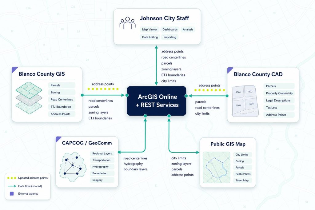
- Shared REST services for address, road centerline, and parcel data
- ArcGIS Online integration for centralized access
- CAPCOG-aligned monthly update workflows
- Updated city limits, ETJ, zoning, and supporting GIS layers
GIS SERVICES PROVIDED
Specialized GIS support across the full addressing workflow
BIS Consulting provided a wide range of GIS services to support the project, from data validation to public web mapping.
911 Address Point Maintenance
BIS assisted in maintaining and validating address points to support CAPCOG 911 mapping requirements.
ArcGIS Online Integration
BIS connected Johnson City’s ArcGIS Online environment with Blanco County GIS resources to improve collaboration and data accessibility.
REST Service Data Sharing
Address points, road centerlines, and parcel data were shared through GIS REST services to keep updated information accessible across systems.
Parcel and Address Verification
BIS coordinated with city staff to identify missing address points, incorrect assignments, and parcels without assigned addresses.
Monthly CAPCOG/GeoComm Updates
BIS supported monthly submission workflows for updated address points and road centerline data.
GIS Layer Updates
The project included updates to city limits, ETJ boundaries, zoning layers, and additional datasets beneficial to the City.
Public GIS Map Interface
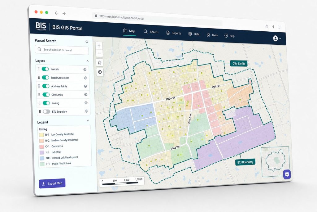
BIS developed a public-facing GIS map interface to improve visibility into parcels and address information.
RESULTS
A stronger, more sustainable GIS operating model
Through the project, Johnson City established a more connected and sustainable GIS workflow that improved collaboration between agencies and strengthened address management processes.
4 Agency Data Coordination
City, County, CAD, and CAPCOG workflows became more connected.
Centralized GIS Access
ArcGIS Online became the hub for shared address, parcel, and boundary information.
Monthly Update Workflow
CAPCOG/GeoComm submissions became part of an ongoing maintenance process.
Public Map Access
Johnson City gained a public-facing GIS map interface for parcel and address visibility.
While additional measurable metrics are still being gathered, the project laid the foundation for long-term GIS accuracy, operational efficiency, and improved interagency collaboration.
WHY IT MATTERS
Accurate GIS data supports far more than maps
For local governments, accurate GIS and addressing data impacts emergency response, utility coordination, permitting workflows, public access to information, and long-term operational planning.
By modernizing its GIS workflows and improving address management processes, Johnson City created a stronger operational foundation for future growth and public service.
The project also demonstrates the value of connected GIS systems that allow cities, counties, appraisal districts, and regional agencies to work from the same reliable data.
Reliable address information supports:
- Faster emergency response
- Better coordination between agencies
- More efficient permitting and utility workflows
- Improved public access to information
- Stronger long-term GIS management
RELATED BIS SERVICES
Focused GIS and local government technology support
BIS Consulting helps local governments maintain cleaner data, publish better maps, and connect GIS systems without adding unnecessary complexity for staff.
GIS Maintenance Services
Keep core datasets accurate, current, and ready for daily use.
ArcGIS Online Services
Configure secure cloud GIS access, sharing, and collaboration.
ETJ and Zoning Layer Management
Maintain boundary and zoning layers with confidence.
Deed Processing & GIS Integration
Turn deed updates into reliable GIS and property records.
Interactive Web Maps
Publish searchable maps for staff, partners, and the public.
Local Government IT Services
Support the systems that keep departments connected.
Property Data Management
Organize parcel, ownership, and assessment data for better decisions.
GIS Data Hosting & REST Services
Host reliable GIS services for applications and agency workflows.
Need a more reliable GIS workflow for your city or county?
BIS Consultants helps local governments modernize 911 addressing, GIS maintenance, ArcGIS Online, REST services, and public mapping systems.